Pantonium’s vehicle fleet management software is designed to provide value to public and medical transportation organizations. However, the route optimization capabilities can also be leveraged to solve common challenges, like finding the best way to experience different landmarks in a city. Let’s say there are six different landmarks in Toronto one would like to visit in the day, at the most optimal hours. What is the best route for discovering the city at the best times? Let’s take a look:
[fusion_builder_container hundred_percent=”yes” overflow=”visible”][fusion_builder_row][fusion_builder_column type=”1_1″ background_position=”left top” background_color=”” border_size=”” border_color=”” border_style=”solid” spacing=”yes” background_image=”” background_repeat=”no-repeat” padding=”” margin_top=”0px” margin_bottom=”0px” class=”” id=”” animation_type=”” animation_speed=”0.3″ animation_direction=”left” hide_on_mobile=”no” center_content=”no” min_height=”none”]
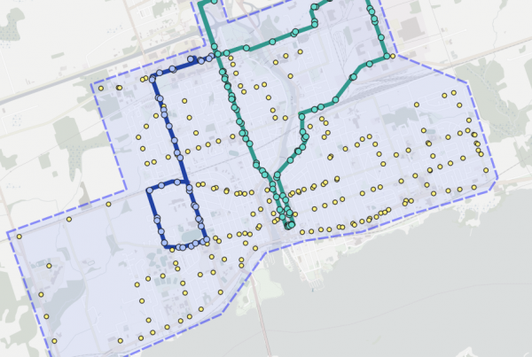
Downtown Toronto
The image above shows all the landmarks we want to visit. Below, we will go through each stop and explain how the route has been optimized:
[/fusion_builder_column][fusion_builder_column type=”1_1″ background_position=”left top” background_color=”” border_size=”” border_color=”” border_style=”solid” spacing=”yes” background_image=”” background_repeat=”no-repeat” padding=”” margin_top=”0px” margin_bottom=”0px” class=”” id=”” animation_type=”” animation_speed=”0.3″ animation_direction=”left” hide_on_mobile=”no” center_content=”no” min_height=”none”]
Union Station to St. Lawrence Market
Our first step is simple. We begin at Toronto’s Union Station, where most travelers will likely start their travels. St. Lawrence Market is only a four minute drive away, or eleven minutes walking. Routing optimization software indicates the quickest route for either method is to move east on Front Street and take it all the way to the market. As St. Lawrence Market opens quite early (5:00am!), this is a great time to head over and grab a famous peameal bacon sandwich to start the day.
[/fusion_builder_column][fusion_builder_column type=”1_1″ background_position=”left top” background_color=”” border_size=”” border_color=”” border_style=”solid” spacing=”yes” background_image=”” background_repeat=”no-repeat” padding=”” margin_top=”0px” margin_bottom=”0px” class=”” id=”” animation_type=”” animation_speed=”0.3″ animation_direction=”left” hide_on_mobile=”no” center_content=”no” min_height=”none”]
St. Lawrence Market to Nathan Philips Square
Our next stop is a little bit more complicated. As we are already in the downtown core, let’s head over to Nathan Phillips Square and check out Toronto’s City Hall. The map above shows several different travel options on the road, with the most efficient route highlighted. This route takes expected traffic into account, providing a travel plan which utilizes city streets to their fullest effect to guide travelers to their destination using the least amount of resources possible. With an average ride-time of only five minutes from St. Lawrence Market, there’s still plenty of time to peruse NPS’s unique architecture and exciting local politics.
[/fusion_builder_column][fusion_builder_column type=”1_1″ background_position=”left top” background_color=”” border_size=”” border_color=”” border_style=”solid” spacing=”yes” background_image=”” background_repeat=”no-repeat” padding=”” margin_top=”0px” margin_bottom=”0px” class=”” id=”” animation_type=”” animation_speed=”0.3″ animation_direction=”left” hide_on_mobile=”no” center_content=”no” min_height=”none”]
Nathan Phillips Square to Casa Loma
Next, we’re taking things out of the downtown core and up to the midtown to Toronto’s famous castle Casa Loma. As before, due to traffic and other constraints, we have multiple routes laid out. The more direct route up Bay Street from Queen Street would usually be the simplest way to navigate the city traffic (with a dip west on Davenport Avenue). However, by optimizing the route on the fly to account for available travel constraints, we can see heading north on University Avenue and taking the scenic route through the University of Toronto, we can beat traffic while taking an equally direct route. Seeing as Casa Loma is only open until 5:00pm and we’ve already been on the road for a few hours, this would be a great time to take in some of Toronto’s most regal architectural history.
[/fusion_builder_column][fusion_builder_column type=”1_1″ background_position=”left top” background_color=”” border_size=”” border_color=”” border_style=”solid” spacing=”yes” background_image=”” background_repeat=”no-repeat” padding=”” margin_top=”0px” margin_bottom=”0px” class=”” id=”” animation_type=”” animation_speed=”0.3″ animation_direction=”left” hide_on_mobile=”no” center_content=”no” min_height=”none”]
Casa Loma to Yonge-Dundas Square
Okay, that’s enough for mid-town; time to get back to the core! Yonge-Dundas Square is akin to Toronto’s version of Times Square, generally featuring live entertainment, demonstrations, performance art, and more in the huge, neon-lit atmosphere. Generally, attractions start to close down around 6:30PM; however, live musical performances with an 11:00PM curfew are common in the summer, so grab a spot on the Jack Astor’s rooftop patio for a panoramic view. Traveling back downtown, we see a variety of routes similar to when we traveled to Casa Loma. Here, we can see the most effective route is one of the most straightforward, but with a key difference: cutting through the University of Toronto helps to reduce traffic waiting time, as one will likely experience traveling south on Spadina Avenue during a busy Saturday evening.
[/fusion_builder_column][fusion_builder_column type=”1_1″ background_position=”left top” background_color=”” border_size=”” border_color=”” border_style=”solid” spacing=”yes” background_image=”” background_repeat=”no-repeat” padding=”” margin_top=”0px” margin_bottom=”0px” class=”” id=”” animation_type=”” animation_speed=”0.3″ animation_direction=”left” hide_on_mobile=”no” center_content=”no” min_height=”none”]
Yonge-Dundas Square to CN Tower
For our last stop, we will observe the breathtaking Toronto night skyline at the CN Tower. With a luxurious top-floor restaurant and tours until 10:30pm, what better way to take in the city you just saw from the ground up? This is one of our most simple routes, as well. Taking St. Patrick south helps beat the University Avenue traffic, with Simcoe Street (with an assist from Lower Simcoe) taking us the rest of the way. This deposits us mere meters from the convenience of Union Station, where we began our journey.
Pantonium is committed to providing the most effect transportation solutions for people anywhere. Our software solutions can be used for non-emergency medical transportation, on-demand bus service, public transit and a variety of other transports. For more information on how we can improve your transit needs, please feel free to email us at info@pantonium.com or give us a call at 1-866-797-0426.
[/fusion_builder_column][/fusion_builder_row][/fusion_builder_container]